


Real Reviews from Real Users


Description
DJI Zenmuse L3
Introducing Zenmuse L3— DJI’s next-generation high-accuracy aerial LiDAR system designed for demanding enterprise and industrial missions. With a long-range 1535 nm LiDAR that can reach up to 950 m even on objects with just 10 % reflectivity, combined with dual 100 MP RGB mapping cameras and a high-precision POS system, this payload is engineered to accelerate large-scale geospatial data collection and deliver rich, accurate data sets for surveying, inspection, infrastructure, and public-safety use.
More than simply “better range,” the L3 also brings enhancements in point-cloud quality (up to 16 returns), wider field-of-view in its imaging system, improved gimbal and POS stability, and a streamlined workflow for processing. Whether it’s large-area terrain mapping, inspection of tall transmission towers, or complex vegetation and built-environment scanning, the L3 aims to deliver “see through, far and true” performance.
With a powerful 1535nm laser and up to 16-return capability, the DJI Zenmuse L3 excels in penetrating dense vegetation and layered environments. Whether capturing ground elevation beneath forest canopies, mapping foliage-covered slopes, or scanning built-up urban zones, the L3 reveals details that traditional sensors struggle to detect. This deep-penetration performance ensures accurate terrain reconstruction and vegetation analysis, making the L3 ideal for forestry, environmental monitoring, land-resource planning, and advanced ecological studies. Even under a thick canopy, critical ground-level data remains visible and measurable.
The DJI Zenmuse L3 is equipped with a powerful 1535 nm long-range LiDAR system, capable of detecting objects at distances of up to 950 meters, even on surfaces with just 10% reflectivity under optimal conditions. This impressive range enables operators to fly at higher altitudes and still capture dense, accurate point-cloud data across expansive areas.
Beyond distance, the system’s smaller laser spot size and high single-pulse energy enhance detail capture and improve LiDAR penetration through dense vegetation, complex terrain, and partially obstructed environments.
With an exceptionally low 0.25 mrad (1/e²) laser beam divergence, DJI Zenmuse L3 produces a much tighter laser spot — roughly one-fifth the size of the Zenmuse L2 at equivalent range. This dramatically improved beam precision enhances the ability to detect and define small, narrow, or distant targets.
The increased energy density of each laser pulse not only improves detail capture but also delivers superior penetration through dense foliage and layered terrain.
With a maximum pulse emission rate of 2 million pulses per second and support for up to 16 returns, DJI Zenmuse L3 delivers exceptionally detailed and reliable spatial reconstruction. This high pulse frequency ensures dense, precise point-cloud capture even at faster flight speeds or higher altitudes, while the multi-return capability allows the system to record multiple layers within a single beam path.
Users can adjust point-cloud density and penetration strength based on mission requirements, enabling optimal performance across varied scenarios — whether conducting high-accuracy topographic surveys, mapping dense forests and rugged terrain, or capturing detailed data.
Supports Linear, Star-Shaped, and Non-Repetitive scanning modes for different operational scenarios:
- Linear: Achieves more consistent point cloud distribution, ideal for high-accuracy terrain mapping.
- Star-Shaped: Balances accuracy with multiple scan angles and penetration capability, well-suited for forests or dense urban environments.
- Non-Repetitive: Provides multiple scan angles and broader coverage, optimized for power line inspections and other complex structural surveys.
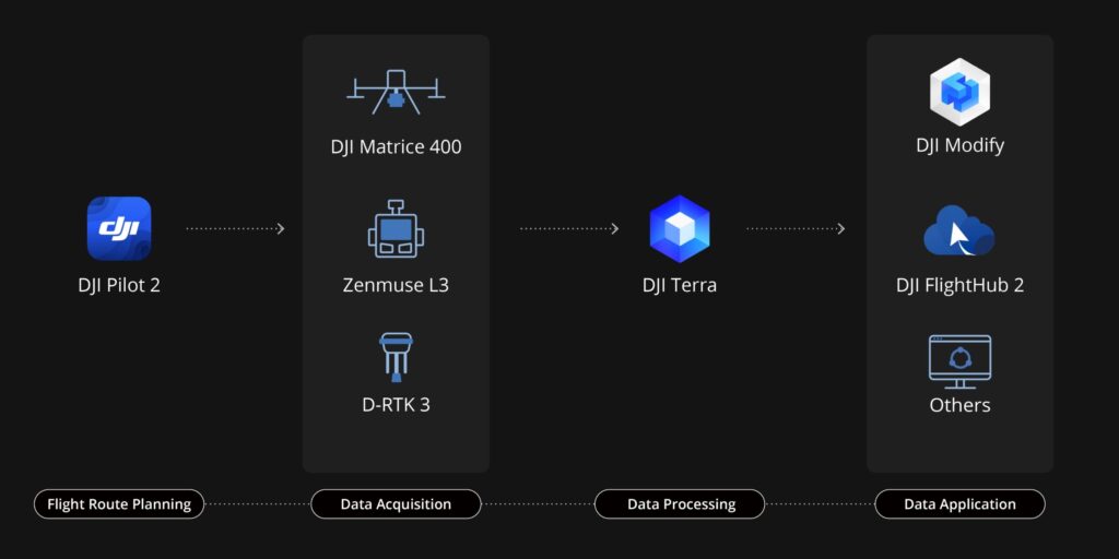
DJI Zenmuse L3 seamlessly integrates with DJI’s ecosystem to deliver an end-to-end mapping solution. From data acquisition and processing to application, this unified workflow is simpler to operate and easier to master than traditional multi-platform setups, helping users efficiently complete a wide range of mapping tasks.
Payment & Security
Payment methods
Your payment information is processed securely. We do not store credit card details nor have access to your credit card information.
Security