


Real Reviews from Real Users


Description
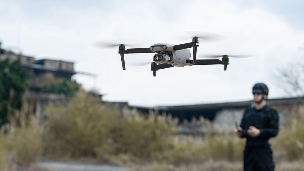
Industrial workers and first responder professionals alike will appreciate the specific qualities of the standard EVO Lite 640T Enterprise Drone from Autel Robotics that are designed to make their jobs easier to perform. The standard version includes an Autel Smart Controller SE V2 with 6" display, which controls a dual gimbal system that includes visible and thermal cameras. People and damaged infrastructure are more easily spotted, and a visual view provides easier navigation to the scene. EVO Lite 640T also offers AI-based recognition and tracking of mobile targets. While flying, 3-way obstacle avoidance keeps the drone safe, and as it records, that data is encrypted and kept from online view. Best of all, the Lite 640T is compact, lightweight, and foldable for rapid deployment and easy storage in a backpack or rucksack.
Standard Version
This is the standard version of the EVO Lite 640T, which includes a single flight battery, USB-C to USB-A data cable, and the Autel Smart Controller SE V2. Its built-in 6" display makes it easy to view a live feed of what the drone sees in both visible and infrared light, in addition to essential flight telemetry. Data can easily be stored on 32GB of built-in storage, but that can be expanded with an optional microSD card up to 128GB. On a full charge, it can run for up to 1.5 hours, but the battery is hot-swappable, so with more batteries you can keep going without downtime.
Dual Gimbal System
The EVO Lite 640T's wide-angle visible light camera can record sweeping and stunningly sharp 4K30 videos or take hi-res 48MP still images. The infrared thermal camera offers 640x512 resolution and can identify temperature signatures down to -4°F and up to 1022°F. Both allow you to stay back and film close-up with a 16x digital zoom.
AI Target Recognition
Either the wide-angle visible or infrared thermal camera can benefit from the drone's AI-based target recognition system. Intelligent AI algorithms and a self-learning system are made to automatically recognize and locate people, cars, and boats, projecting their positions on a map.
Long Range Transmission
Comfortably fly to remote locations thanks to the drone's ability to transmit 1080p30 video from up to 7.5 miles away. This is made possible by the use of tri-band adaptive frequency hopping. Whether 2.4 GHz, 5.2 GHz, or 5.8 GHz, the drone will automatically select the best channel based on electromagnetic interference. Footage that should come in smooth with a sub-200 ms latency.
Autel Enterprise App
- Split-Screen: Visible light, infrared, and map images are supported with dual-channel simultaneous output on-screen. Compare each for a more comprehensive analysis of an area.
- Customizable Toolbar: Selections can be customized to personalize your piloting experience by making frequently accessed functions easily to operation.
- Offline Maps: Supporting the pre-loading of maps, this feature helps you continue the mission with precise flight positioning, even if you're in an area with low or no wireless connectivity.
Data Security
- Privacy Protection: Flight logs, locations, and other user privacy data requires consent to upload.
- Encrypted Storage: Supporting AES encryption, photos, videos, and flight logs will require a password to access.
- Video Live Streaming: The RTMP protocol for live streaming is supported and provides remote real-time viewing and analysis. GB28181 support is scheduled for future updates.
Additional Features
- Up to 40 minutes of flight time
- Up to 40 mph horizontal flight speed
- Up to 1.9-mile maximum takeoff altitude
- SDK ecosystem with support for Mobile SDK (MSDK)
- Supports Autel's Enterprise flight software for single-person deployment
Key Specs
| Maximum Flight Time | |
| Remote ID | |
| Camera System | |
| Maximum Video Resolution | |
| Still Image Support | |
| Sensing System | |
| Control Method | |
| Weight |
Performance
| Maximum Horizontal Speed | |
| Maximum Ascent Speed | |
| Maximum Descent Speed | |
| Maximum Wind Resistance | |
| Maximum Take-Off Altitude | |
| Maximum Flight Time | |
| Maximum Hover Time | |
| Maximum Tilt Angle | |
| Hovering Accuracy | |
| Maximum Angular Velocity |
Aircraft
| Rotor Configuration | |
| Remote ID | |
| Aircraft I/O | |
| Operating Conditions |
Imaging
| Number of Cameras | |
| Camera System | |
| Zoom | |
| Minimum Focus Distance | |
| ISO Sensitivity Range | |
| Night Vision | |
| Shutter Speed | |
| Maximum Video Resolution | |
| Still Image Support | |
| Photo Modes | |
| Media/Memory Card Slot | |
| Internal Storage |
Gimbal
| Number of Axes | |
| Rotation Range | |
| Follow Speed | |
| Stabilization Accuracy |
Avoidance/Sensing System
| Sensing System | |
| Sensing System Capabilities |
Remote Controller / Transmitter
| Control Method | |
| Transmission System | |
| Maximum Operating Distance | |
| Transmitter I/O | |
| Clean Video Output | |
| Battery Type | |
| Operating Temperature | |
| Mobile App Compatible | |
| Built-In Display | |
| Dimensions |
Flight Battery
| Battery Chemistry | |
| Battery Capacity | |
| Battery Configuration | |
| Maximum Charging Power | |
| Operating Temperature | |
| Storage Temperature | |
| Charging Temperature | |
| Weight |
Charger
| Input Power | |
| Output Voltage | |
| Power Rating |
General
| GNSS Support | |
| Overall Dimensions | |
| Weight |
Packaging Info
| Package Weight | |
| Box Dimensions (LxWxH) |
Items Included
- Autel Robotics EVO Lite 640T Enterprise Drone (Standard)
- Autel Smart Controller SE V2
- Flight Battery
- Battery Charger
- USB-C to USB-A Data Cable
- Limited 1-Year Manufacturer Warranty (Excluding Battery & Propellers)
- Limited 1-Year Manufacturer Warranty (1-Year for Battery with Less Than 200 Charges, Whichever Comes First)
Payment & Security
Payment methods
Your payment information is processed securely. We do not store credit card details nor have access to your credit card information.
Security